The Indigenously Developed Technology
4/16/20248 min read
The indigenously developed technology consists of:
- More than 500 illustrated figures prepared on complex factors, with only about 100 presented here.
- Over 300 sensors featuring location-specific attributes.
- Otter boards that do not perform as expected in relation to their three positional angles, resulting in the net not being opened horizontally.
Additionally, the development has led to:
A. Improvements in otter board design and functionality.
B. The development of new Energy Integration Processes (EIPs) for a better systematic analysis of complex and interdisciplinary natural processes.
C. The emergence of new applications, including investigations and experiments for the analysis and evaluation of natural systems.
D. The applicability of the technology across more than a dozen prime areas in open nature.
E. The preparation of technical and operational details in more than a dozen PowerPoint presentations.
F. The implementation of this technology in over 700 R&D institutions, including ICAR, CSIR, DRDO, DOES, IITs, NITs, ONGC, GSI, universities, NGOs, and survey agencies.
G. The use of the technology for more systematic analysis of complex processes.
H. A case that received international acclaim from the United Nations.
I. The provision of simple and effective solutions to many standard and expensive methods widely used internationally.
The importance of related R&D work is underscored by the following achievements:
No other countries have managed to acquire such critical underwater data with the same essential 15 parameters of the otter trawl system, which remains the most popular and active fishing gear. Developments in this area by other countries have been reported in "Modern Fishing Gear of the World, Vol. 1 & 2," published by Fishing News Books Ltd. for the FAO of the United Nations. Further details, including unique features, are available in Annex-F.
A particularly significant case, which became an international challenge, involves a more location-specific and practical approach: UMT, depicted in Figure 5 on page no. 5, developed in 1985 and published in the National training course organized by CIFT exclusively for this purpose. Additional related information is available in the CIFT library and with me.
For studies on Post-Harvest Technology (PHT), behavior studies of marine animals, and fisheries hydrography, a list of other instruments is provided. Details are available in Book-1, published by CIFT in 2007.
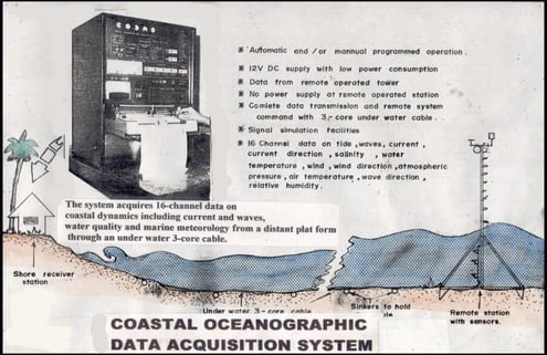
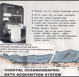
Another unique development is the Coastal Oceanographic Data Acquisition System (CODAS), developed for CESS-Thiruvananthapuram to facilitate coastal engineering processes through systematic studies of coastal protection measures. The novel technical features of this system include: 1. No battery usage at the remote location. 2. The 16-channel data collected and processed concerning water quality, water dynamics, coastal oceanography, marine meteorology, etc., were transmitted to a data logger situated in a coastal laboratory on land, through a long 3-core cable. More details can be found in Annex-G. Both cases stand out for their unique design concepts, which did not require any power supply inside the remote system.
Figure 11: CODAS developed for the Centre for Earth Science Studies (CESS), Thiruvananthapuram, for scientific evaluation and implementation of coastal protection processes. Specialty: no power is required at the remote tower. All the 16 data points are sent to a data logger on land through a single 3-core cable. A data multiplexer at the remote tower scans all the 16-channel data.
Among the various instrument systems developed, including more than 400 illustrated cases that pertain to over a dozen prime areas mentioned on page no. 5, the most significant is UMT, depicted in Figure 5. Developed in the initial days of R&D activities by the author, UMT stands out for several reasons:
1. The analysis of the otter trawl system emerged as a significant challenge in fishing technology, as documented in various chapters of "Modern Fishing Gear of the World, Vol. 1 & 2."
2. While many countries attempted to analyze the otter trawl system using the same methodology, they could only document four or five parameters of the system.
3. Unlike other attempts, the discussed method allows for the collection of complete 15-channel data instantaneously during the operation, rather than post-operation analysis of recorded data.
4. Instantaneous access to these data enables systematic analysis of the otter trawl system and the provision of applied information to the fishing industry.
5. Real-time underwater data allows the ship's skipper and crew to make immediate corrective measures for any malfunctions, particularly with the underwater net and its accessories.
6. Potential malfunctions identified include:
- Otter boards not performing as expected in their three positional angles, preventing the net from opening horizontally.
- Otter boards ploughing into the bottom mud during bottom trawling, leading to an excess load on the meter.
- Distortion of mesh shapes due to incorrect rigging, causing extra strain.
- The tearing off of the cod-end, resulting in the escape of fish from the net.
- Unequal tension on both sides due to improper lengths of ropes paid out, as indicated by the load on the meter.
Through the development of sensors and measurement techniques, it's now possible to measure respective parameters and make necessary corrections. No other equipment developed in advanced countries offers performance analysis of the otter trawl system with as many operational parameters as those reported by CIFT, which includes 15 operational parameters.
The importance of this R&D work is further emphasized by the fact that no other countries have been able to acquire underwater data with such essential parameters of the otter trawl system. These developments, compared to other countries', are documented in "Modern Fishing Gear of the World, Vol. 1 & 2" by Fishing News Books Ltd. for the FAO of the United Nations, with additional unique features detailed in ANNEX-F.
Another notable development is CODAS (Coastal Oceanographic Data Acquisition System), designed for CESS-Thiruvananthapuram to aid in coastal engineering processes through the systematic study of coastal protection measures. Both CODAS and UMT are distinguished by their innovative design concepts, notably the absence of an internal power supply in the remote system.
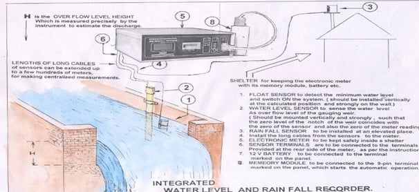
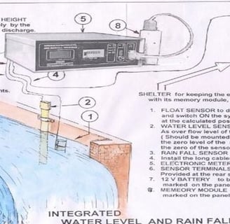
Figure 12: Integrated system for measuring rainfall + water level + water discharge + suspended silt + total quantity of silt contained in the discharged water.
The system was developed for the National Technological University in Ratnagiri, Maharashtra, showcasing a wide range of observational techniques that have been reported. These techniques are part of over 500 cases illustrated and developed by the author, initiated at ICAR-CIFT. The innovative approach used for analyzing the hydrodynamic performance of the otter trawl system garnered significant appreciation from the FAO of the United Nations during a seminar in Canada in 1988.
Subsequently, this methodology informed the design of five postgraduate-level subjects across five different universities, each focusing on distinct topics. Additionally, it was applied in various projects at different levels, including Dam Safety of KSFE, IRDB (Irrigation Design Research Board) of the Kerala Government, NCST, INCOH, INCH, and others. While the concept was systematically implemented in many instances, it faced obstacles in others due to preconceived notions and commitments of the stakeholders involved.
The basic approach encompasses a comprehensive system combining Sensors, Electronic Signal Conditioners, Signal Processors, EIP (Energy Integration Processors), and new applications. These elements facilitate new investigations and experiments relevant to natural resources across multiple disciplines:
1. Ocean Technology
2. Agricultural Sciences
3. Fisheries Technology
4. Fisheries Hydrography
5. Greenhouse Studies
6. Coastal & Harbor Engineering
7. Dam Safety & Its Hydro-Meteorology
8. Architectural & Structural Engineering
9. Soil & Water Conservation Engineering
10. Meteorology, and others.
This holistic methodology underpins a range of applications, from the analysis of complex systems in ocean technology to innovations in agricultural and fisheries sciences, underscoring the versatility and impact of the developed systems in addressing diverse challenges across environmental and engineering domains.
Figure 13: Hydro-Meteorological Data Acquisition System equipped with several other related sensors for automatic data acquisition from the atmosphere, soil, plants, different heights of the atmosphere, water, air temperature (AT), relative humidity (RH), wind, solar radiation, wind gust, and reflected radiation, with an additional facility for the Energy Integration Process (EIP) for the energy parameters of solar radiation and wind velocity. This is an improvement on conventional Automatic Weather Stations (AWS) with limited parameters. All sensors are equipped with remote measurement facilities, enabling centralized measurements from around 1000 meters. The system has already been implemented in many locations with different designs tailored to specific locations. The indigenously developed observational technology allows for the design of numerous models of weather stations and hydro-meteorological stations suited to various applications. More details are available in Annex-H.
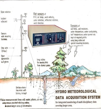
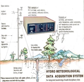
Figure 14: AWS (Automatic Weather Station) installed in Kolkata, equipped with two layers of sensors and operated with solar power. Recently, two such stations have been installed in the Peechi forest for the Kerala Forest Research Institute (KFRI).
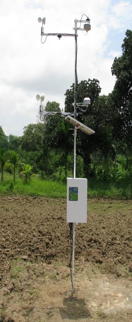
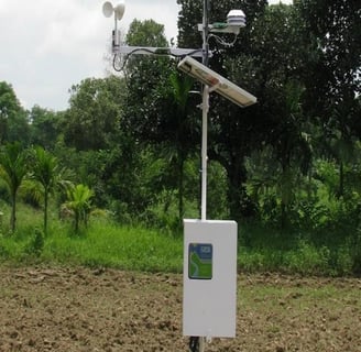
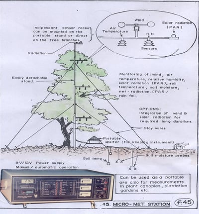
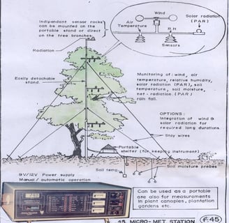
Figure 15: Micro-Met Tower developed for investigations on canopy parameters in relation to other atmospheric and soil conditions. This includes technical features to measure many important parameters from the canopy, soil, plant atmosphere, etc.
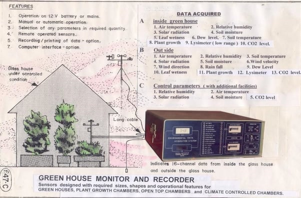
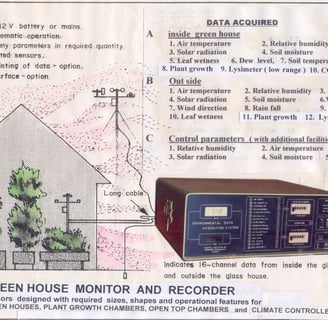
Figure 16: Greenhouse Monitor and Recorder developed for investigations in agricultural practices under controlled atmospheric conditions at Tamil Nadu Agricultural University (TNAU).
Figure 17: Influence of CO2 in the three Open Top Chambers (OTCs) using the electronic infrastructure developed and installed at Tamil Nadu Agricultural University (TNAU), based on global warming in agricultural practices. This figure shows how the parameters are controlled in the OTCs.
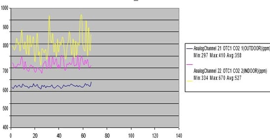
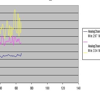
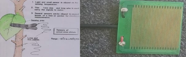
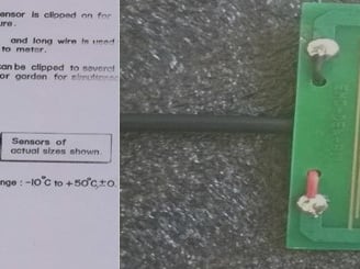
Figure 18: Leaf Temperature Sensor and Figure 19: Leaf Wetness Sensor were developed for disease forecasting studies in agriculture, taken up by different centers of Kerala Agricultural University (KAU). The Leaf Wetness Sensor is always exposed to open air, similar to leaves, and hence, the parameter is equally important for these studies.
Figure 20: Miniature Size Wind Sensor developed with a non-contact inductive pickup for use inside small plant canopies. It features fast response, a very low distance constant, high portability, and easy installation.
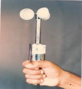

Figure 21: Soil Permeability Meter with test soil filled in a 20 cm diameter, tall PVC pipe embedded with special SM (Soil Moisture) sensors and a data logger attached. Water is made to infiltrate through the soil. A real-time graph is prepared showing the characteristic soil permeability.
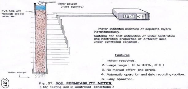
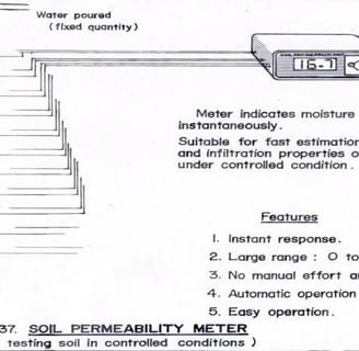
Figure 22: Calibration graph of soil moisture, based on the gravimetric principle, with a sensor operating on the response impedance principle. The analysis shows that it is exceptionally linear over its full useful range.
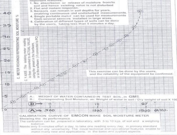
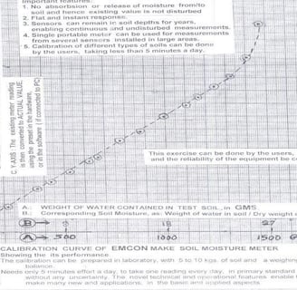
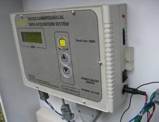
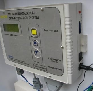
Figure 23: Micro-Climatological Data Acquisition System developed for Kerala Agricultural University, Thrissur, complete with its sensors.
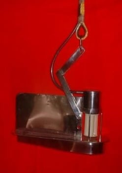
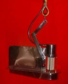
Figure 22: Calibration graph of soil moisture, based on the gravimetric principle, with a sensor operating on the response impedance principle. The analysis shows that it is exceptionally linear over its full useful range.