Details of the Technologies
4/16/202411 min read
The development and technological implementation of electronic field-operated systems at various locations and times have seen significant contributions and leadership from key individuals, emphasizing the collaborative nature of these ventures. These operations, known for their complexity and high-risk factors, include several critical aspects:
A. Implementation of Large Systems in Remote Locations: This involves setting up sophisticated systems in challenging environments such as ocean depths, oil rigging platforms, and forests. These tasks require not only a high degree of technical knowledge and expertise but also the ability to adapt to the unique conditions and requirements of each site.
B. Maintenance and Customization: Frequent visits to these remote locations across the country are necessary for repairs, modifications, and customizations of the installations. This ensures that the systems meet the specific needs of each customer. Additionally, essential training is provided to staff at these sites to enable them to operate and maintain the systems effectively. These demanding tasks have been managed and led by notable figures:
1. Shri T.D. Joshy: Initially, the leadership and execution of these challenging tasks were undertaken by Shri T.D. Joshy, in his capacity as a Partner of EMCON. Under his guidance, numerous systems were successfully implemented in various remote locations.
2. Shri T. S. Sreejith: The mantle of leadership later passed to Shri T. S. Sreejith, who has continued to direct these efforts as the Managing Director. His contributions have been significant, including the development of many new sensors and systems that have enhanced the capabilities and effectiveness of field-operated electronic systems.
The implementation of electronic field-operated systems in remote and challenging environments is a daunting and indispensable component of these development activities. These systems are meticulously designed to withstand and function in diverse and often harsh conditions, including ocean depths, forests, agricultural sites, and dam locations. The efforts and innovations of individuals like Shri T.D. Joshy and Shri T. S. Sreejith have been pivotal in overcoming the numerous challenges associated with these endeavors, showcasing a commitment to excellence and a profound impact on the field.
Figure 24: Gimbal Stabilized Shipborne Marine Meteorological Station developed and installed on the research ship of DRDO-NPOL, Kochi. This AWS is equipped with gimbal-stabilized facilities for sensors to render them unaffected by the ship's roll and pitch, ensuring the collection of undisturbed data. Many systems at remote locations required special facilities and location-specific alterations. The sensors deployed in the water were lifted up when the ship moved.
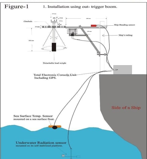
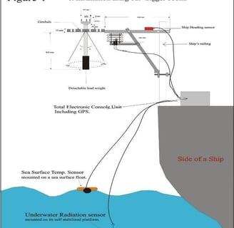
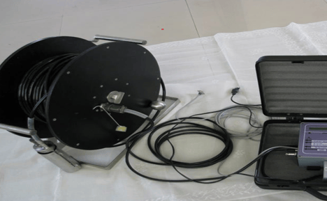
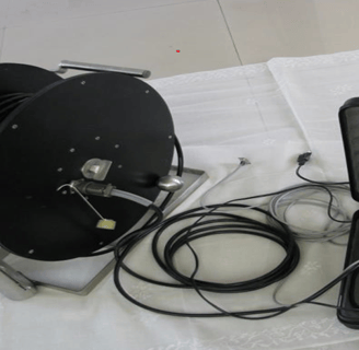
Figure 27: Heading-Tilt-Depth Recorder developed for DRDO-NPOL, Cochin, to record the operational parameters of their underwater testing platform operated at a depth of 100 meters
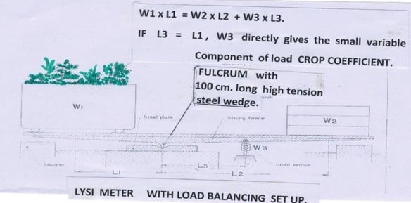
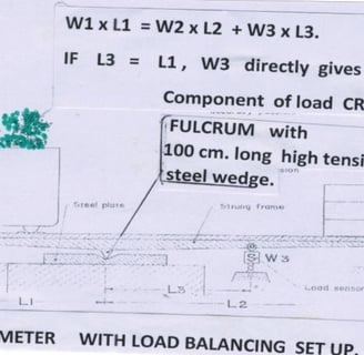
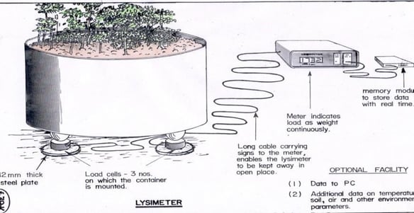
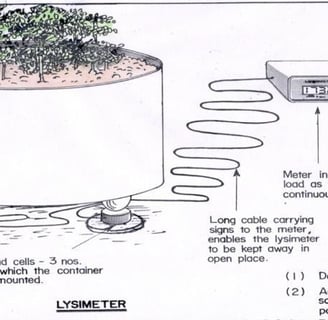
Figure 28: Lysimeter experiments in agricultural research were conducted with a load balancing setup for estimations of the Crop Coefficient in agriculture. Separate types of experiments can also be conducted in open areas. Such important experiments enable the analysis of integrated growth of plants, including their root system, along with other related conditions. The weight balancing setup provides high accuracy in measuring weight changes. "W3," as shown in the figure, represents further increases in weight caused by the growth of plants in the pan "W1." The data can be fed to a data logger to record it in real time or at selected intervals, allowing for graphical or tabular presentation.
Figure 29: Lysimeter with total weight measured directly without weight balancing. The weights of the three legs are separately measured to obtain the total weight, which is then fed into the data for analysis.
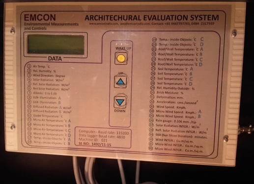
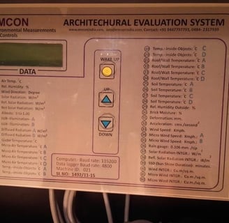
Figure 30: Line Quantum Sensor developed for making average measurements over a 120 cm length x 2 cm wide area, suitable for all components of solar radiation types including PAR (Photosynthetic Active Radiation), infrared, total incident radiation, ultraviolet, etc. Calibration is required, especially useful for measuring radiation at the shades of plants.
Figure 31: Above-Architectural Evaluation System developed with its several sensors for the evaluation of different functional features of buildings, including comfort parameters. This system has been implemented in institutions such as NIT Calicut (NITC), NIT Karnataka (NITK), College of Engineering Trivandrum (CET), Madurai University, and TKM Engineering College, Kollam, among others.
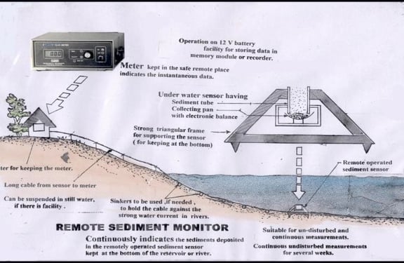
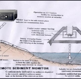
Figure 32: Remote Sediment Monitor developed for the estimation of sediments in dams, backwaters, rivers, etc., continuously with data displayed and stored on SD cards as programmed.
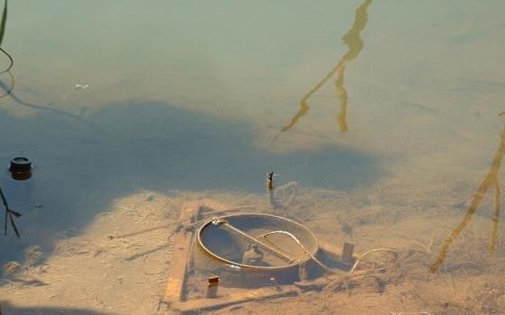
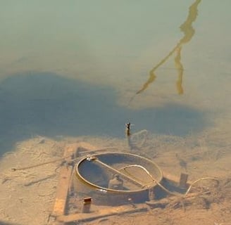
Figure 33: Photograph taken after three years, showing the Manimalayar river in Thiruvalla when the water receded.

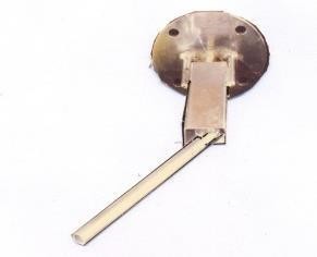
Figure 34: Photograph of the Hydrodynamic Tilting Lever Sensor developed for use inside penstock pipes, for sensing the flow rate without requiring rotating parts and also providing excellent linearity in performance. This sensor has been installed in many locations by the Kerala Water Authority and also in Mysore.
Facilities needed for the systematic analysis of various related natural parameters have been developed and implemented in more than 700 R&D institutions affiliated with ICAR, CSIR, DRDO, DOES, IITs, NITs, ONGC, GIS, and many university departments. This has enabled scientists, technologists, and engineers to conduct numerous new investigations and experiments in open nature. Details are provided in Annex-I.
The systematic analysis of various natural parameters has been greatly enhanced by the development and implementation of specific facilities across more than 700 R&D institutions. These institutions include prestigious organizations such as the Indian Council of Agricultural Research (ICAR), Council of Scientific and Industrial Research (CSIR), Defence Research and Development Organisation (DRDO), Department of Ocean Development (DOES), Indian Institutes of Technology (IITs), National Institutes of Technology (NITs), Oil and Natural Gas Corporation (ONGC), Geological Survey of India (GSI), and numerous university departments. This widespread implementation has empowered scientists, technologists, and engineers to conduct new investigations and experiments in the open nature, significantly advancing research and development in various fields. For more detailed information, Annex-I provides comprehensive insights.
In terms of contributions through R&D projects, from the beginning of his career, the individual in focus recognized the importance of making technology and its benefits accessible to end users. The technologies developed were commercialized through the National Research Development Corporation (NRDC) of India and transferred to several firms, including KELTRON and EMCON. He spearheaded numerous projects sponsored by the Department of Electronics (DOE), the Agricultural Engineering Department of ICAR, the Department of Science & Technology (DST), among others, in addition to the standard projects of the Central Institute of Fisheries Technology (CIFT). These projects covered a wide range of applied areas, aligning with the mainstream activities of the country. They aimed at demonstration and direct delivery of products to various R&D institutions from CIFT. This initiative has facilitated the implementation of the technology in over 700 R&D institutions affiliated with ICAR, CSIR, IITs, NITs, ONGC, DRDO, GSI, DOES, as well as colleges of engineering technology and applied sciences, thereby significantly contributing to the technological and scientific advancement within the country.
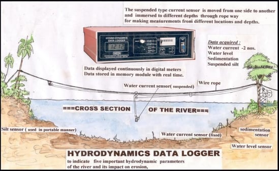
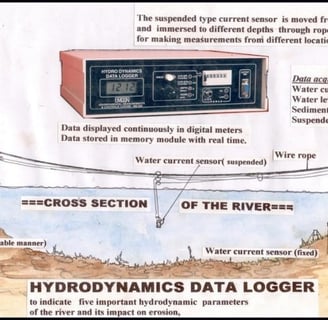
Figure 35: Hydrodynamics Data Logger developed for the SWCE Division of Kerala Agricultural University (KAU) and installed at the Research Center – Thiruvalla, in connection with the study of the water dynamics of the Manimalayar river and the protection of the river banks with geotextiles, as needed by Professor Anil Kumar. Some of the sensors were operated through a cable ropeway across the river in order to cover all the horizontal and vertical points of the dynamic parameters of the river, with a width of more than 150 meters.
The sensors developed and utilized in these systems exhibit a range of specialized features designed to enhance their functionality and adaptability across various applications, particularly in challenging environments:
1. Remote Operation Capability: These sensors can operate remotely, acquiring data from an area approximately 1 kilometer in diameter. This feature enables centralized measurements, facilitating extensive monitoring without the need for physical presence at multiple points.
2. Multi-channel Measurement: The ability to perform multi-channel measurements from remote locations via a long 3-core cable enhances the system's versatility, allowing for the simultaneous collection of diverse data types.
3. No Power Supply Required at Remote Locations: A distinctive feature of these sensors is their ability to function without a direct power supply at the measurement site, as illustrated in figures 4 through 11. This reduces the logistical complexity and cost associated with deploying and maintaining the sensors in remote or inaccessible areas.
4. Low Impedance and High Electrical Noise Immunity: The sensors are designed with low impedance values and high immunity to electrical noise, which makes them resistant to environmental noise. This ensures the accuracy and reliability of the data collected, even in electrically noisy environments.
5. Uniform Signal Ranges: All sensors feature uniform signal ranges, which allows for signal conditioning in a uniform manner and integration into a common format. This standardization simplifies the data processing and analysis stages.
6. Underwater Durability Without Special Enclosures: The underwater sensors are engineered to withstand hydrostatic pressure without the need for special enclosures, enabling them to be directly exposed to water at various depths.
7. Durability with Low-cost Cabling: The use of low impedance sensors eliminates the need for costly and braided-type silicon cables, ensuring that the system remains operational for several years with minimal maintenance requirements.
8. Applicability to Large Projects: The unique technical features of these sensors make them suitable for implementation in large projects across diverse areas, with more than 150 notable applications.
These specialized characteristics underscore the innovative approach taken in the development of these sensors, highlighting their potential to significantly contribute to various fields of research and development, environmental monitoring, and other applications requiring precise and reliable data collection under challenging conditions.
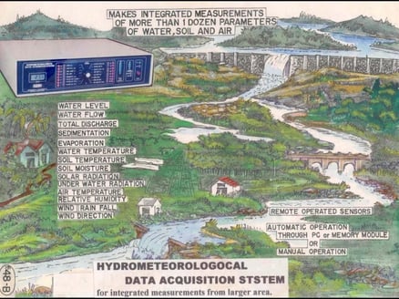
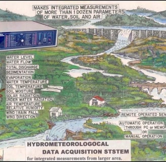
Figure 36: Hydro-Meteorological Data Acquisition System developed for the National Institute of Hydrology (NIH)-Roorkee, for a holistic study of the Nainital reservoir in Uttar Pradesh. The sensors were developed with unique technical features, including a long cable attached with low impedance values of sensors, to withstand probable high environmental noise and enable accurate centralized measurements.
Development of New Sensors with Location-Specific Features, While Encountering Problems at Remote Prime Locations
Many new sensors and observational systems have been developed to address the challenging problems encountered at such locations. Examples include:
1. Figure 15: Sensor development for Uttar Pradesh (UP).
2. Sensor development for Oil and Natural Gas Corporation (ONGC).
3. Underwater observation of test platforms of the Defence Research and Development Organisation - Naval Physical and Oceanographic Laboratory (DRDO-NPOL) at 100m depths.
4. Figure 16: Measurement of average radiation across large plant canopies.
5. Figure 17: Sensor for omnidirectional radiation response inside greenhouses in Tamil Nadu Agricultural University (TNAU).
6. Figure 18: Energy Information Processor (EIP) for the precise and automatic estimation of energy parameters of solar radiation and its several components, wind velocity, wind gust, and ocean waves, etc.
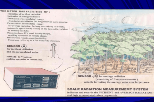
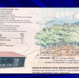
Figure 37: SRMS (Solar Radiation Measurement System) developed and installed for the Rubber Research Institute of India (RRII) in Kottayam. This system has facilities for measurements of:
A. Incident Solar Radiation,
B. Average Radiation at the shades of large plant canopies,
C. Integrated values of both A and B over long selected periods, up to years continuously.
The system developed for RRII, Kottayam, and installed provides totalized values of both A and B by accounting for the fast fluctuations of the radiation values caused by cloud formations, as shown in Fig. 14 above. The Energy Integration Process (EIP) takes care of such inherent and hidden factors, which normally cannot be estimated. All data are recorded automatically without any manual efforts. The average radiation is obtained by connecting 5 separate sensors in series following a certain procedure. The reliability of this new method can be tested and evaluated by simulation.
Details about the specialty of average radiation are provided in Annex-J.
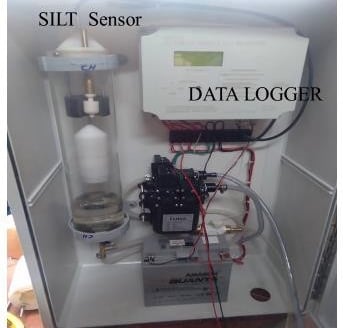
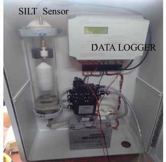
Figure 38: Automatic Silt Recorder System for Rivers, Canals, Coastal Waters, Backwaters, Dams, etc., operates by automatically sucking water from the locations and measuring the silt content, following standard methods for:
A. Recording data with real-time in solid state.
C. Transmitting the data wirelessly to other selected recipients.
Silt measurements can also be done manually using a Silt Sensor, with the facility to deploy the sensor down to required depths from a boat, bridge, etc., up to 300 m using its long cable.
The total components, including the Silt Sensor, Data Logger, 12V battery power supply, and pump to suck silty water from the water body, are enclosed inside a container.
Novel Agri-Based Sensors Developed for:
1. Incident radiation,
2. Average radiation at the shades of a large canopy (Fig. 22),
3. PAR value for Photosynthetic Active Radiation,
4. Diffused radiation at the shades of greenhouses with omnidirectional property,
5. Net radiation,
6. Underwater radiation,
7. Albedo value of objects, and
8. Other components including Infrared radiation, Ultraviolet radiation.
Note: All the sensors have been developed with an additional facility for remote measurements in a large garden, city, etc., for centralized measurements.
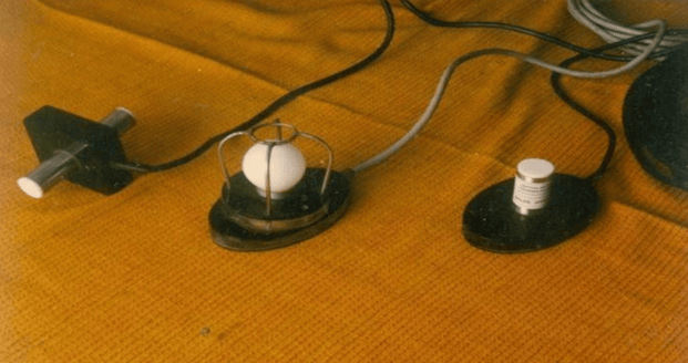
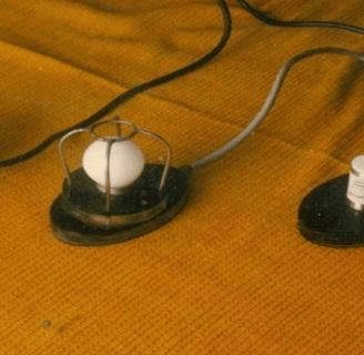
Figure 39-A: Solar Radiation Sensors Developed with Different Designs. Sensors were tailored for specific applications, each attached with long cables to enable centralized measurements from a large garden, city, etc. Three distinct designs of solar radiation sensors have been developed for:
1. Dual sensing, looking upward and downward, to estimate both incident and reflected radiation continuously, with data fed continuously to a data logger or computer. This data can be further utilized for other related applications.
2. Designed for measurements inside greenhouses, where radiation is diffused without any specific direction, this sensor possesses omnidirectional properties to capture radiation from all directions.
3. For underwater measurements related to the photosynthesis of aquatic/marine organisms or in aquaculture ponds, with the sensor immersed at various depths.
Solar Radiation Monitor and Integrator developed and installed in many R&D institutions involved in solar energy-related investigations. The EIP (Energy Integration Process) can be utilized to make automatic estimations of the total value of energy contained in Watts/sq.m., for selected durations from minutes to days, months, and years, also accommodating the fast fluctuations of radiation values. The same EIP process can be applied to all other energy parameters, including all the separate components of solar radiation, average radiation as shown in Fig. 16, wind velocity, wind gust, ocean waves, tide, underwater radiation, etc.
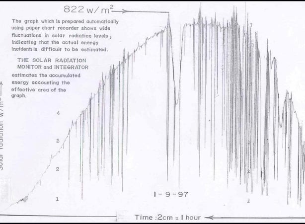
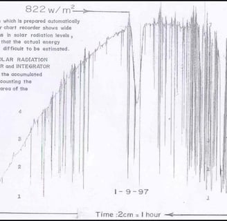
Figure 40: Shows the fast fluctuating nature of solar radiation and how the EIP (Energy Integration Process) developed could automatically solve and process the fast fluctuating solar data to give the total energy incident over long durations, over any selected durations up to years, accounting for all the fast fluctuations, without requiring any manual effort, in digital format. Such complex data involving too much irregular changes in values, typically found in energy parameters including solar radiation and its components, wind velocity, wind gust, etc., cannot be processed following conventional methods to obtain their total resultant values.
A. Currently, there is no better method to obtain the exact value of solar radiation.
B. This method employing EIP makes the estimation precisely and automatically, incident over any selected durations from minutes to years. The EIP (Energy Integration Process) developed makes the estimation automatically for all energy parameters in nature, including solar radiation and its components, PAR values, reflected radiation, infrared radiation, ultraviolet radiation, wind velocity, energy values over any selected intervals, wind gust, ocean waves, tide, etc.